
Bundaleer
Enjoy, explore, preserve Bundaleer Reservoir Reserve
Important information
If you’re planning to explore Bundaleer Reservoir Reserve, be aware that naturally occurring blue-green algae is currently present, with warmer weather conditions.
The reservoir reserve remains open to visitors, but we advise that contact with untreated water with levels of blue-green algae can be harmful to your health, so always wash your hands after contact with the water, and if you drop a line, be sure to clean your fish thoroughly.
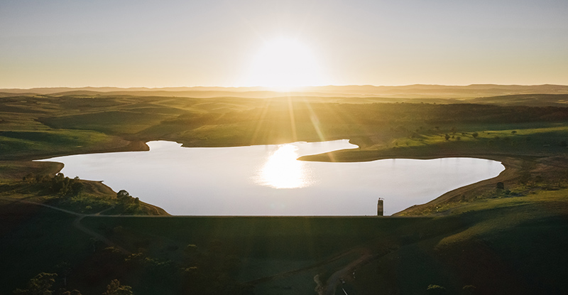
Located about a 40 minute drive from Clare, Bundaleer is a smaller reservoir reserve where you can fish, kayak, enjoy views of the water from the loop walking trail and have a picnic.
At a glance
 Open daily, sunrise to sunset. Closed on Total Fire Ban Days, Christmas Day, and for operational activity (gates will be closed).
 Car park
 Walking/running
 Fishing - permit required
 Cycling
 Kayaking/canoeing
 Picnicking
 Wildlife and birdwatching
 Automated External Defibrillator
 Accessible toilets
 No dogs (assistance animals allowed)
Activities and facilities
To prepare for your visit, please check the conditions of access.
Walking/running
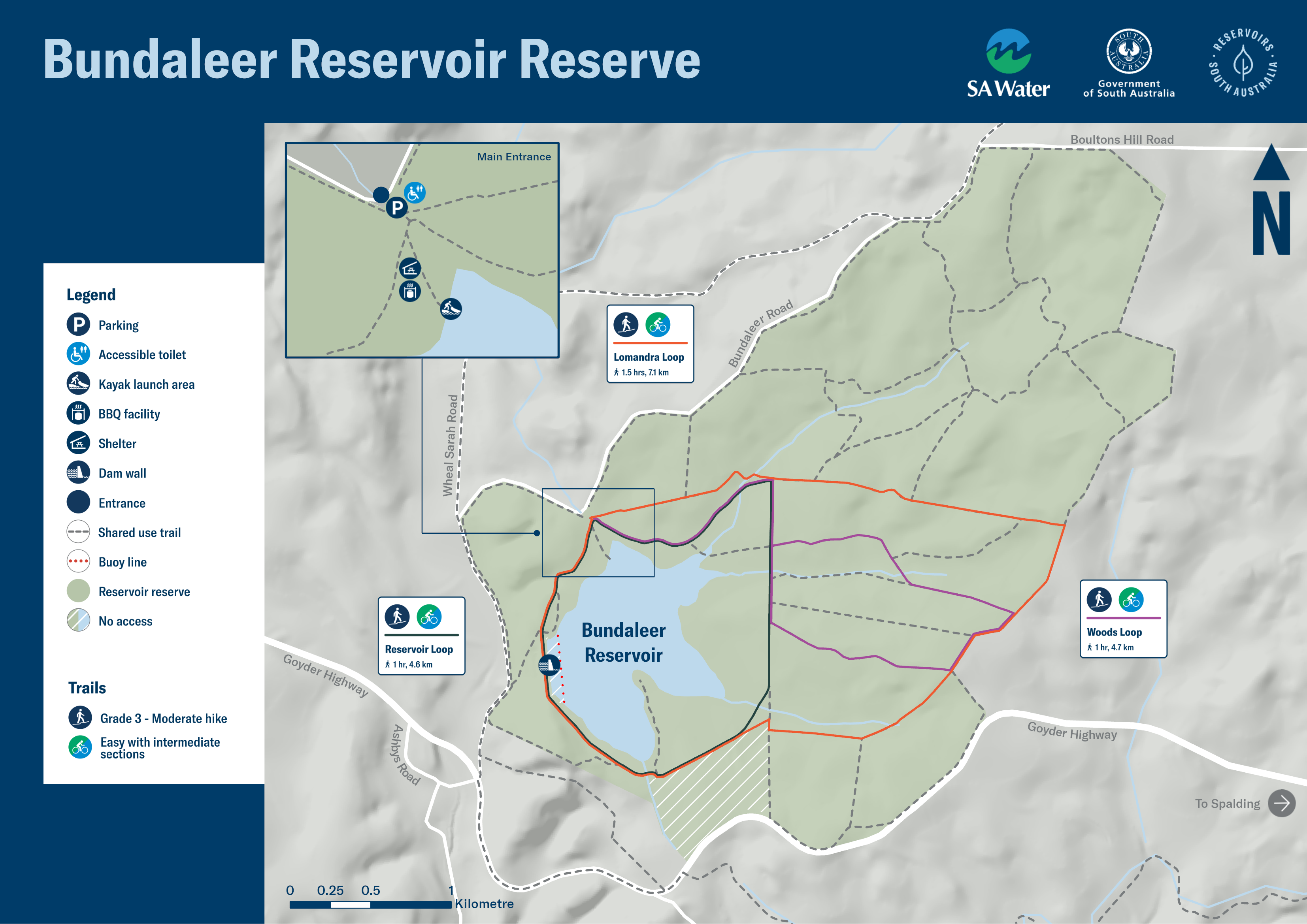
There are three unsealed trail loops suitable for walking and running: The 4.5km Reservoir Loop takes you around the reservoir itself, including the dam wall.
The 7km Boundary Loop also crosses the dam wall but ventures further out around the outer reserve, and the 6km Woods Loop leads you along the northern shores and into the woodlands. The trail down to the picnic area from the carpark is hard packed gravel with a few slight rises that may require some assistance.
Fishing
With a fishing permit, you can drop a line in the from the shoreline in the fishing zone, or from a kayak or canoe.
Bundaleer Reservoir is stocked with golden perch, silver perch, rainbow trout and brown trout. Fishing limits are detailed on PIRSA's website.
Cycling
The reservoir reserve’s three loop trails, totalling 17.5km, take you around the reservoir, the reserve boundary or the woodlands. You can also combine them and explore additional trails that cross through the woodlands. The trails are shared by walkers and cyclists, so please be considerate of other trail users.
Kayaking/canoeing
Take to the water on your kayak or canoe and enjoy the surrounding bushscape from the water. To drop a line from your kayak or canoe, you will need a fishing permit.
Picnicking
There are two picnic shelters overlooking the kayak launch area along the Bundaleer loop trails to stop and take in the serenity.
![]() With the exception of assistance animals, dogs are not welcome at reservoir reserves as they can carry harmful organisms that can easily contaminate the water and present a risk to the safety of the drinking water. Dogs also pose a threat to local native birds and wildlife.
With the exception of assistance animals, dogs are not welcome at reservoir reserves as they can carry harmful organisms that can easily contaminate the water and present a risk to the safety of the drinking water. Dogs also pose a threat to local native birds and wildlife.
Blue-green algae
Algae is a common occurrence in open water sources, including reservoirs and the River Murray, especially during warmer months of the year when conditions are favourable for growth.
SA Water samplers, operators and scientists actively monitor and test the source water and connecting water networks during these times and adjust treatment processes as needed. This ensures they continue to supply safe, clean drinking water to their customers.
Some blue-green algae species produce compounds which can be harmful to humans and animals. Contact with untreated water in a reservoir where algae are present can be harmful to your health.
When blue-green algae levels are increasing, and related water treatment or algal management activities are being conducted, the site will be closed to visitors until 1pm that day. There will be clear signage at the entrance and on this website page.
To find out more, read SA Health’s information about blue-green algae health impacts and how to avoid illness.
Click map below for a print-friendly version.
Maps on your mobile
If you have a smartphone or tablet you can download the free Avenza Map app and have interactive reservoir reserve maps on hand when you need them.
The app uses your device’s built-in GPS to plot your real-time location within the reserve onto a map. The app can be used without a network connection and without roaming charges. You can also measure area and distance, plot photos and drop placemark pins.
How to get it working on your device:
1. Download the Avenza Maps app from the app store (iOS/Android) whilst you are still in range (its free!).
2. Open up the app and click the shopping cart icon.
3. Click ‘Find’ and type the name of the reservoir reserve you are looking for.
4. Click on the map you are after and install it (all our maps are free).
5. You will now find a list of your installed maps on the home page of the Avenza Maps app.
6. Use our maps through the Avenza Mapa app while in the reserve and never take a wrong turn again.
What sets Bundaleer Reservoir apart
Capacity: 6.3 gigalitres (one gigalitre is one billion litres), which is enough to fill more than 3,100 Olympic swimming pools
Constructed: 1898-1903
Bundaleer Reservoir was built to supply Snowtown, Redhill, Brinkworth, Narridy, Blyth and Port Wakefield and was an important source of water in the region for local towns and agriculture until the Morgan-Whyalla pipeline was completed in 1944.
Supplementing supply from Beetaloo , Bundaleer also helped secure water supplied for the lead smelters in Port Pirie while maintaining water supply to the local towns.
Little known fact about Bundaleer Reservoir
During construction, a temporary town housed the workers. The town had three butchers, three bakers, three cool-drink sellers, a shoemaker, draper, doctor’s surgery, police station made from three marquees, a cricket club, a galvanized iron schoolroom, single men’s tents and married men’s camp, plus several boarding houses. A Salvation Army officer travelled by bicycle every Thursday from Jamestown to visit the temporary town.
Water quality
Bundaleer Reservoir is one of 16 across South Australia.
Treating drinking water before it’s supplied to homes, businesses, schools, hospitals and more, is important to make sure it is clean and safe to drink straight from the tap. You can learn how SA Water treats water and maintains the quality its customers value and rely upon.
Bundaleer is a contingency supply reservoir.
At a glance
- Open daily, sunrise to sunset. Closed on Total Fire Ban Days, Christmas Day, and for operational activity (gates will be closed).
- Car park
- Walking/running
- Fishing - permit required
- Cycling
- Kayaking/canoeing
- Picnicking
- Wildlife and birdwatching
- Automated External Defibrillator
- Accessible toilets
- No dogs (assistance animals allowed)